*This article confirmed the information in November 2022.
Hateruma Island is an island with a circumference of about 15km, and is the southernmost island in Japan where people live. Hateruma Island is too big to walk so, many people rent a bicycle for sightseeing.
If you are sightseeing by bicycle, it will take a full day. The tourist attractions of Hateruma Island are scattered all over the island.
・There is a beautiful beach if you go through a road that is not even on Google Maps.
On this page, we will introduce recommended tourist attractions on Hateruma Island, such as beautiful beach where you can swim and beach made of coral fragments.
Contents
♦ Nishihama Beach
♦ Court Mori
♦ Monument of The Southernmost Part of Japan
♦ Cape Takanazaki
♦ Pemuchi Beach
♦ Coral Beach
♦ Hamashitan Habitat (Mousaki Beach)
♦ Recommended tourist attraction map
♦ Package tour with bus sightseeing
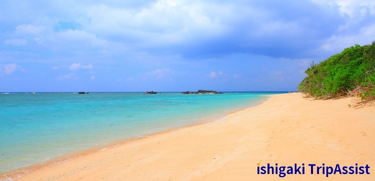
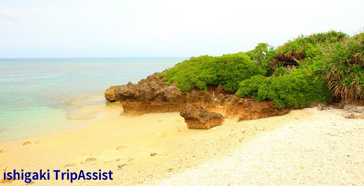
Nishihama Beach
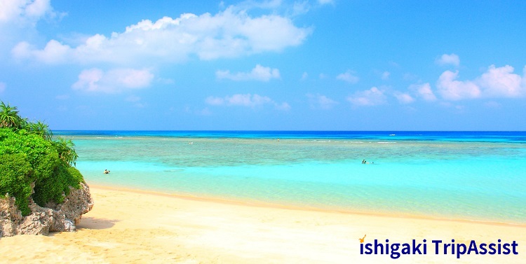
This is the most famous tourist attraction on Hateruma Island. You can swim in the beautiful sea called “Hateruma Blue”. If you are lucky, you can also see sea turtles. This beach is calming just by looking at it.
There are showers and toilets on the beach, and there is also a snorkeling goods rental shop near the beach. However, there is no life guard, so be careful and enjoy yourself. In addition, there are no vending machines or shops on the beach, so food and drink need to be prepared.
Business Hours
Always (Free)
Map No.
About 5 minutes by bicycle from the port
Map No. 1
instagram
Court Mori
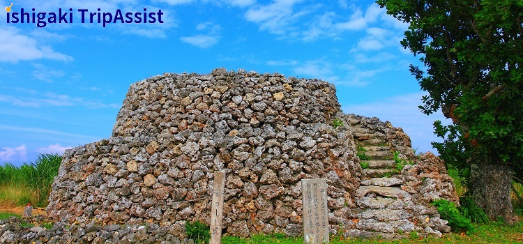
This is a hill made of rocks that was once used to monitor the ocean. It is protected as a cultural property of Japan.
Business Hours
Always (Free)
Map No.
About 7 minutes by bicycle from the port
Map No. 2
instagram
Monument of The Southernmost Part of Japan
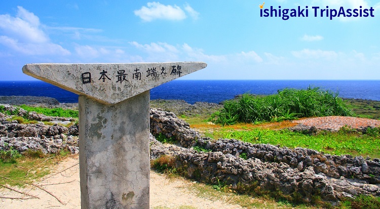
This is a popular photography spot. This monument is written in Japanese as “the southernmost part of Japan”. It will be a memorial to the southernmost island in Japan where people live.
Business Hours
Always (Free)
Map No.
About 25 minutes by bicycle from the port
Map No. 3
instagram
Cape Takanazaki
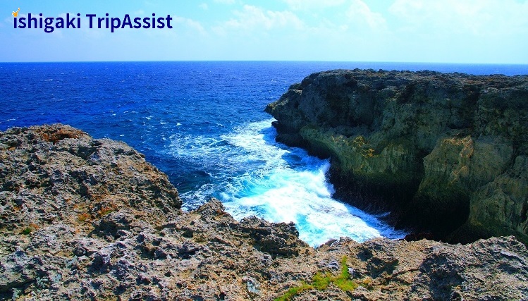
In Cape Takanazaki, which is right in front of the southernmost monument in Japan, you can see the powerful scene of big waves crashing against the cliffs. You can see a completely different sea from the calm sea such as Nishihama Beach.
You need to walk on the raised coral rocks to get close to the cliffs. Sandals are dangerous because the coral rocks are sharp, so wear shoes.
Business Hours
Always (Free)
Map No.
About 25 minutes by bicycle from the port
Map No. 4
instagram
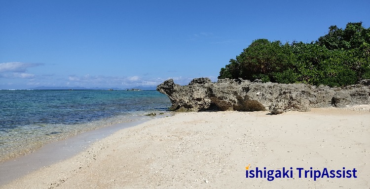
Pemuchi Beach
This is located in the south of Hateruma Island and is the southernmost beach in Japan. It is a quiet beach with few visitors because there is no information board. However, you are not allowed to swim here due to the fast currents. Therefore, there are no toilets or showers.
You can get star-shaped sand (star sand) here, which is said to bring good luck. Therefore, it’s a good idea to enjoy the beautiful sea on the beach.
There is no information board at the beach entrance, so you can reach the beach by checking the approximate location on the map and entering the bushes that seem to be connected to the sea. The entrance is the break in the bush as shown in the photo below.
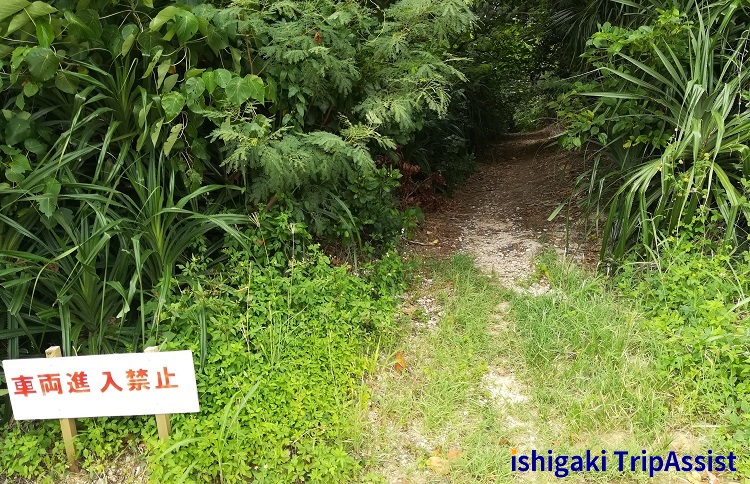
Business Hours
Always (Free)
Map No.
About 20 minutes by bicycle from the port
Map No. 5
instagram
Coral Beach
It is a small beach located to the west of Hateruma Island. It is a mysterious beach where the sand of the beach is not sand but coral fragments. This is a natural product, and I wonder why it is not sand only here. The white parts in the photo above are all coral fragments, and the brown parts are sand.
You are not allowed to swim here and there are no toilets and showers.
There is no information board at the beach entrance. Therefore, you can reach the beach by checking the approximate location on the map and entering the bushes that seem to be connected to the sea. The entrance is the break in the bush.
Business Hours
Always (Free)
Map No.
About 15 minutes by bicycle from the port
Map No. 6
instagram
Hamashitan Habitat (Mousaki Beach)
Mousaki Beach is located to the west of Hateruma Island and is a small beach with tree called “Hamashitan”, which is hundreds of years old.
There is no information board at the beach entrance. Therefore, you can reach the beach by checking the approximate location on the map and entering the bushes that seem to be connected to the sea. The entrance is the break in the bush.
Business Hours
Always (Free)
Map No.
About 13 minutes by bicycle from the port
Map No. 7
instagram
Recommended tourist attraction map
In consideration of going to the major tourist attractions of Hateruma Island by bicycle, information on uphill is also provided on the map. If you go sightseeing from No.1 on the map, you can avoid going uphill and you can comfortably go sightseeing by bicycle. However, since the village is on a hill, think of the road from the road along the coastline to the village as an uphill.
In addition, Hateruma Island has few public toilets, so we added the location of the toilets to the map.
Package tour with bus sightseeing
There is a one-day package tour that includes a round-trip ferry fare between Ishigaki Island and Hateruma Island and bus sightseeing fee. These package tours are recommended for those who want to travel around tourist attractions efficiently by bus.
These tours are offered by the tour company in Ishigaki Port Ferry Terminal. If you would like to take a tour, you can book at the website below, by phone or at the shop counter.
Tour company
Anei Kanko Ferry
Ishigaki Island Travel Center (only in Japanese)